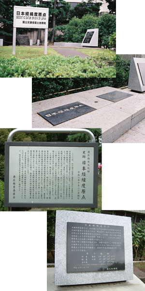
It is here that the Japan Geodetic Datum was established to serve as a reference for determining the standard for the country's longitude and latitude.
The revised longitude of the Geodetic Datum was announced by the Ministry of Education in 1918 as "139゜44'40.5020" E, longitude, and 35゜39'17.5148" N, latitude". However, in 2002, due to the revision of the amended Survey Act, the latest space geodetic techniques were utilized to establish the new longitude and latitude as "139゜44'28.8759"E, longitude, and 35゜39'29.1572"N, latitude".
From 1874, the origin point was determined to be at the Tokyo Naval Observatory, but in 1888, it became the Tokyo Astronomical Observatory affiliated with the Astronomical Phenomenon Observatory of Tokyo University which integrated with the Geographical Bureau of the Ministry of Home Affairs in Tamaike Aoi-cho, Akasaka-ku. The origin point was in the center of the "Meridian Circle", an instrument used by the Astronomical Observatory.
In 1923, the Tokyo astronomical observatory moved to Mitaka but the "Meridian Circle" remained with the Geographical Survey Institute (GSI), as the Japan Geodetic datum, and at present it is utilized as Japan's origin of geographical measurement.
The Japan Geodetic Datum was not only the origin of the Japan Geodetic Coordinate System, but also the starting place of Japan's Astronomical Observatory and a place of deep interest for science technology and history as well as culture and historical significance.
MINATO City Board of Education