|
 |
 |
The area around Roppongi has many hills. Geographically, Roppongi is on elevated ground so if you go in any direction from the Roppongi crossing, you will go downhill. It sits on higher ground so that you can overlook the surrounding areas. In the old days, it was a Samurai residence, but recently embassies and other such buildings line the streets in the area.
We would like to introduce the many faces of the hills of Roppongi in the changing seasons. |
|
| |
 |
|
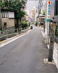
"Nadare" was written with three different kanji combinations. Or maybe the name was chosen because there was a landslide there (Nadare also can mean avalanche).
It also had other names such as "Sachikuni-Zaka" and "Ichibei-Zaka"
|
|
 |
|
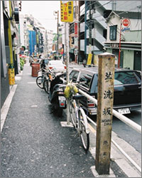
Evidently, the uphill road behind Azabu police station was thought to be Imoarai-Zaka but another road that went uphill to the Roppongi crossing, which was built after the Meiji period, was actually Imoarai-Zaka (washing potatoes hill). There was a potato wholesale store there, thus the name.
|
|
 |
|
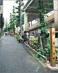
In the beginning of the Meiji period, Kasumi town named after Kasumiyama Inari Shrine (presently Sakurada Shrine) was built and in 1887 a road was made through the town and named Kasumi-Zaka.
|
|
|
|
|
 |
|
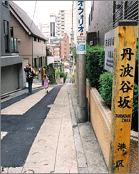
In the Genna period, bannerman Okabe, Govenor of Tanba residence was built and the bottom of the hill was called Tanbadani. In the beginning of the Meiji period, the road opened and it was named after the valley.
|
|
 |
|
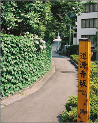
Dogenji temple was built at the top of the hill in the beginning of the Edo period.
The road was named after the temple and called Dogenji-Zaka or Dogen-Zaka
|
|
 |
|
From the Meiji period to the year Taisho 3, there was a musical hall (a Yose) called Fukui-tei on the way up the hill on the north side up the hill and this is how this road came to be called Yose-Zaka.
|
|
|
|
|
 |
|
The slope of the hill became slack in the middle and then it went downhill, giving it a look of a flat "Otafuku" face (a moon face) and this is how the road was named Otafuku-Zaka.
|
|
 |
|
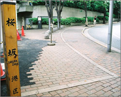
In the middle of the Meiji Period, a new road was made and at the bottom of the hill just before the war damaged area was a large Sakura tree which gave this road its name.
|
|
 |
|
A new road opened around the year Meiji 20. Ichibei town named after the village headman and Mikawadai-machi where the Matsudaira, Govenor of Mikawa, Tadanao's residence stood, used the first kanji character from each town to make this road's name.
|
|
|
|
|
 |
|
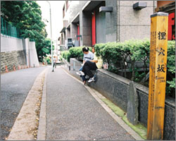
Mami was a kind of female raccoon dog, flying squirrel or badger. And a long time ago, there was a hole, "ana" (said to be dug by a badger) at the bottom of the hill. This is how the name of the road came to be. (There was also a theory that the hole was a mining pit.)
|
|
 |
|
Until the middle of the Edo period, on the left side of a hill, was the estate of the Daimyo Torii (feudal lord).
The road opened around the first year of the Genroku Period (1688).
|
|
 |
|
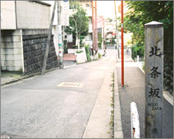
Near the bottom of the hill on the south side was the Daimyo Hojo family's villa and this is how the name came to be.
|
|
|
|
|
 |
|
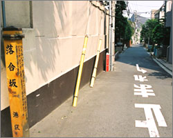
Going down the hill to Gazenbodani, there was a spot where people who were coming and going from the Akasaka direction would run into each other and that is why this road was called Ochiai-Zaka. (There is also another theory about the spot. )
|
|
 |
|
In the Edo Period, because there were a lot of hinoki (Japanese cypress) trees, the Yamaguchi clan Mori Estate (presently the Military defense・Hinoki-cho Park), was called the Hinokiyashiki (Cypress Residence), and the hill also took the name.
|
|
 |
|
Until around the end of the Tenmei Period (1788), there was an udon shop called "Matsuya Ihei" so the hill came to be called Udon-Zaka.
Sometimes, it is mistaken for the old Imoarai-Zaka.
|
|
|
|
|
 |
|
Because there were roads that ran into the slope from both sides, it was presumed the reason why this road was called Ikiai-Zaka. However, it is not certain because the slope was between Ichibei-machi and Iikura-machi.
|
|
|
|
|
|
|
|
|
|
|